 Centre for Polar Studies
World
Type of resources
Topics
Keywords
Contact for the resource
Provided by
Representation types
Update frequencies
status
Scale
-
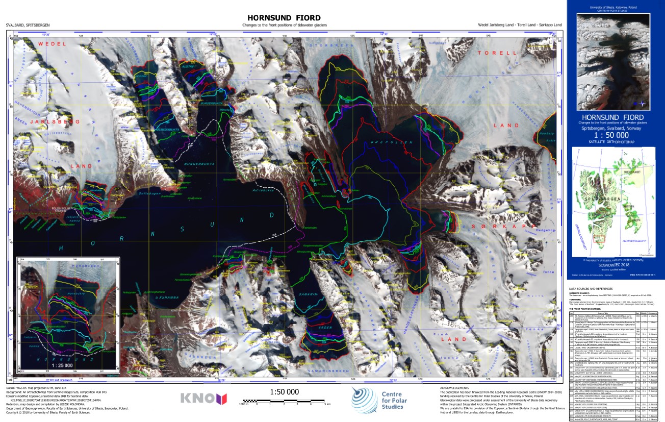
The ortophotomap of Hornsund Fiord with changes to the front positions of tidewater glaciers. The front positions are based on different cartographical maps and satellite data. The base map is Sentinel 2 satellite image acquired on 6 July 2018. Citation: Kolondra L., 2018. Hornsund Fiord - Changes to the front positions of tidewater glaciers. University of Silesia, Faculty of Earth Sciences.
-
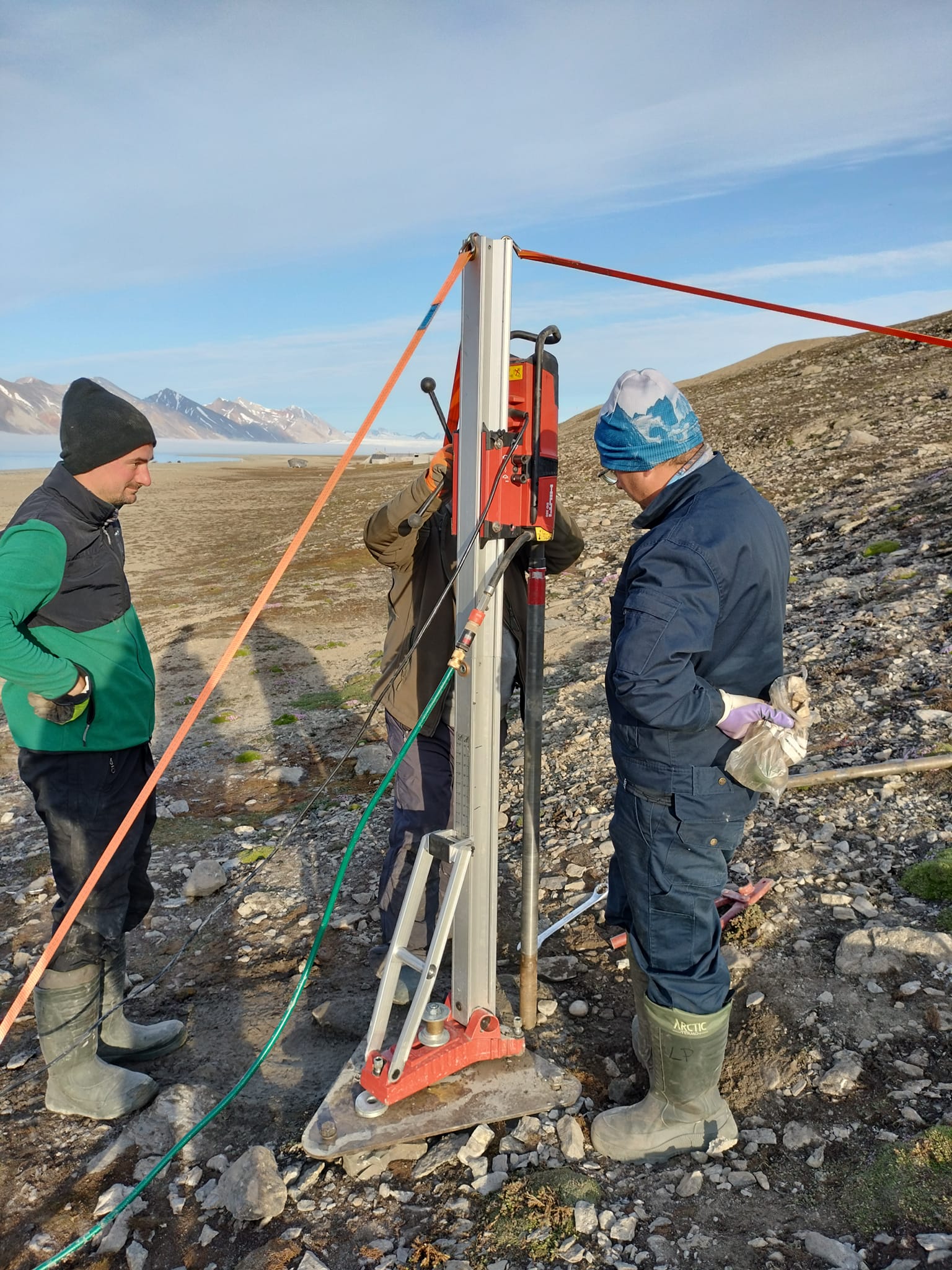
Permafrost monitoring System of thermistors (temperature strings with loggers) to monitor the ground thermal state Precise data on the thermal state of the frozen ground is one of the key missing components of the environmental monitoring at the research stations spread across Spitsbergen. The CRIOS project will allow us to equip the newly established borehole with precise temperature strings that will record ground thermal changes over the next couple of years. A system of temperature strings will be used in the monitoring of the thermal state of permafrost in drilled boreholes. Devices were tested in severe weather and are commonly used for permafrost monitoring by other research groups working in polar regions. The hole in the vicinity of the UAM station in Petuniabukta was delineated at a distance of about 50 m from the shoreline, in the zone between the Polish and Czech stations. The drilling was carried out on 22-23.07.2023. The bedrock is built up by siltstone and sandstone. At the drilling site, they are covered by thick-bedded beach sediments. During the drilling, a depth of 7 meters below sea level was reached, and with no further drilling progress, a decision was made to install a string to the depth obtained. CRIOS – Cryosphere Integrated Observation Network on Svalbard Project financed from the EEA Financial Mechanism 2014-2021 operated by the National Science Centre in Poland Agreement no. UMO-2022/43/7/ST10/00001 to a predefined project no. 2022/43/7/ST10/00001 Project period: 08.09.2022 - 30.04.2024 (2029)
-
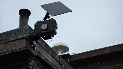
Time-lapse cameras In order to determine the state of coverage of the area, e.g. period of snow cover on a tundra, the extent of the glacier front, etc., it is necessary to perform photographic imaging at a specific time interval. This will allow for precise diagnosis of snow conditions. The camera is installed at the main entrance to the NCU Polar Station. The lens is pointed in a westerly direction, towards Prins Karls Forland CRIOS – Cryosphere Integrated Observation Network on Svalbard Project financed from the EEA Financial Mechanism 2014-2021 operated by the National Science Centre in Poland Agreement no. UMO-2022/43/7/ST10/00001 to a predefined project no. 2022/43/7/ST10/00001 Project period: 08.09.2022 - 30.04.2024 (2029)
-
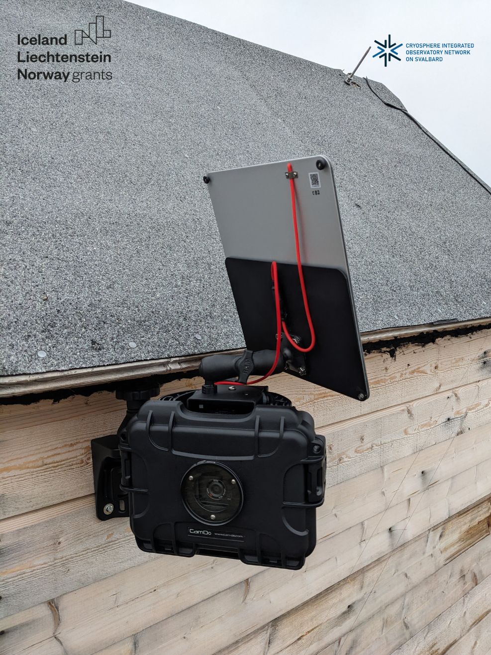
Time-lapse cameras In order to determine the state of coverage of the area, e.g. period of snow cover on a tundra, the extent of the glacier front, etc., it is necessary to perform photographic imaging at a specific time interval. This will allow for precise diagnosis of snow conditions. CRIOS – Cryosphere Integrated Observation Network on Svalbard Project financed from the EEA Financial Mechanism 2014-2021 operated by the National Science Centre in Poland Agreement no. UMO-2022/43/7/ST10/00001 to a predefined project no. 2022/43/7/ST10/00001 Project period: 08.09.2022 - 30.04.2024 (2029)
-

Permafrost monitoring System of thermistors (temperature strings with loggers) to monitor the ground thermal state Precise data on the thermal state of the frozen ground is one of the key missing components of the environmental monitoring at the research stations spread across Spitsbergen. The CRIOS project will allow us to equip the newly established borehole with precise temperature strings that will record ground thermal changes over the next couple of years. A system of temperature strings will be used in the monitoring of the thermal state of permafrost in drilled boreholes. Devices were tested in severe weather and are commonly used for permafrost monitoring by other research groups working in polar regions. On the coastal section selected for drilling at Calypsobyen, the bedrock contains siltstone and sandstone forming relict abrasion platforms, which are currently covered by loose sand and gravel beach sediments. The borehole was located near the mouth of the Scott River (right bank), at a distance of about 75 m from the shoreline and 900 m from the station. After stopping the drilling progress again at 5 m below sea level, a decision was made to install a string in the third hole. CRIOS – Cryosphere Integrated Observation Network on Svalbard Project financed from the EEA Financial Mechanism 2014-2021 operated by the National Science Centre in Poland Agreement no. UMO-2022/43/7/ST10/00001 to a predefined project no. 2022/43/7/ST10/00001 Project period: 08.09.2022 - 30.04.2024 (2029)
-

Permafrost monitoring System of thermistors (temperature strings with loggers) to monitor the ground thermal state Precise data on the thermal state of the frozen ground is one of the key missing components of the environmental monitoring at the research stations spread across Spitsbergen. The CRIOS project will allow us to equip the newly established borehole with precise temperature strings that will record ground thermal changes over the next couple of years. A system of temperature strings will be used in the monitoring of the thermal state of permafrost in drilled boreholes. Devices were tested in severe weather and are commonly used for permafrost monitoring by other research groups working in polar regions. Site Information The borehole near the UMK station in Kaffioyra was located at the existing meteorological garden, about 100 m from the shoreline. The drilling was carried out on 20-21.07.2023. The substrate is dominated by loose sandy-gravel beach sediments. A large amount of fine material and the formation of a core in a small part of the hole made it possible to reach a depth of 10.0 m below sea level. CRIOS – Cryosphere Integrated Observation Network on Svalbard Project financed from the EEA Financial Mechanism 2014-2021 operated by the National Science Centre in Poland Agreement no. UMO-2022/43/7/ST10/00001 to a predefined project no. 2022/43/7/ST10/00001 Project period: 08.09.2022 - 30.04.2024 (2029)
-
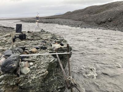
Time-lapse cameras In order to determine the state of coverage of the area, e.g. period of snow cover on a tundra, the extent of the glacier front, etc., it is necessary to perform photographic imaging at a specific time interval. This will allow for precise diagnosis of snow conditions. The camera is installed in the glacier catchment area at the hydrological station. CRIOS – Cryosphere Integrated Observation Network on Svalbard Project financed from the EEA Financial Mechanism 2014-2021 operated by the National Science Centre in Poland Agreement no. UMO-2022/43/7/ST10/00001 to a predefined project no. 2022/43/7/ST10/00001 Project period: 08.09.2022 - 30.04.2024 (2029)