 Centre for Polar Studies
asNeeded
Type of resources
Available actions
Topics
Keywords
Contact for the resource
Provided by
Years
Formats
Representation types
Update frequencies
status
Scale
-
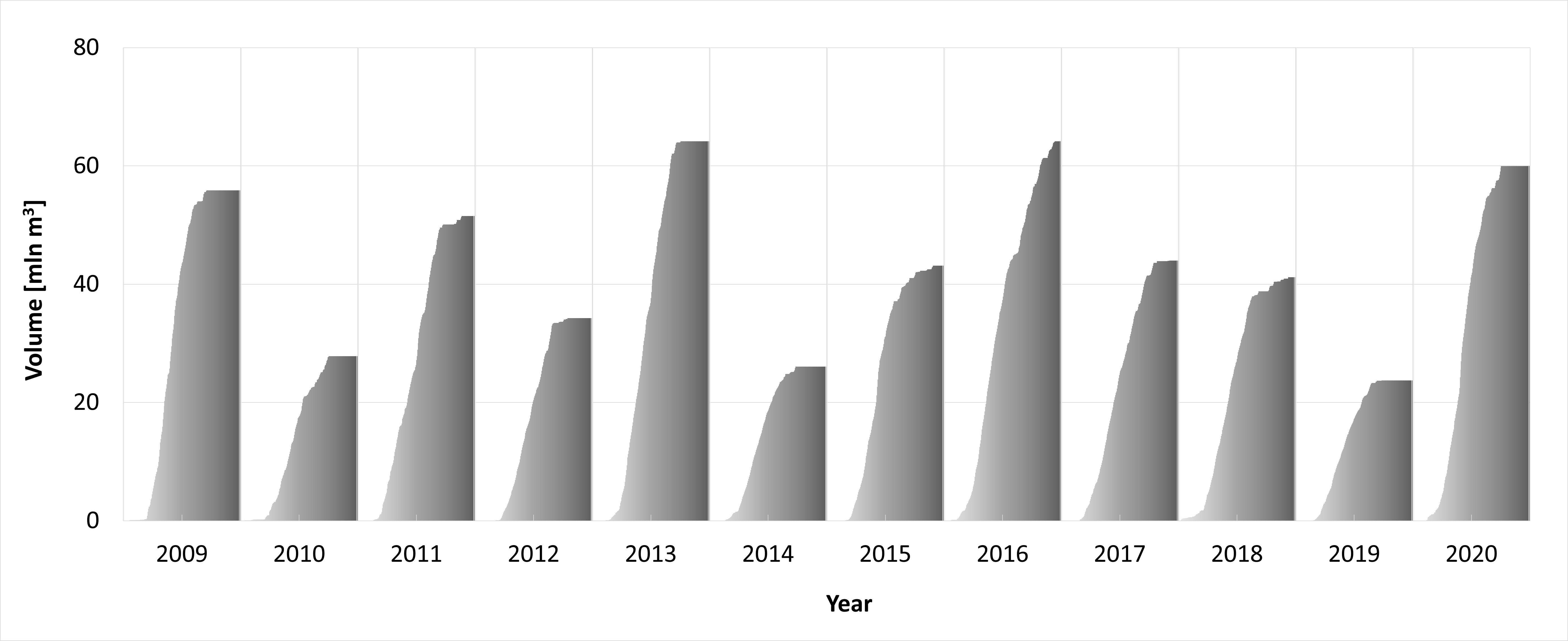
On the basis of glaciological and meteorological data collected on Werenskioldbreen, daily surface ablation for the period May - November for years 2009-2020 was calculated (PPD, temperature ablation model). The dataset includes part of the results from the project “Hindcasting and projections of hydro-climatic conditions of Southern 350 Spitsbergen” (grant no. 2017/27/B/ST10/01269) financed by the Polish National Science Centre, “Arctic climate system study of ocean, sea ice, and glaciers interactions in Svalbard area”—AWAKE2 (Pol-Nor/198675/ 17/2013), supported by the National Centre for Research and Development within the Polish–Norwegian Research Cooperation Programme and the SvalGlac—Sensitivity of Svalbard glaciers to climate change, the ESF Project, the project Integrated Arctic 355 Observing System (INTAROS)- Horizon 2020, the ice2sea 7th FP projects. The studies were carried out as part of the scientific activity of the Centre for Polar Studies (University of Silesia in Katowice) with the use of research and logistic equipment of the Polar Laboratory of the University of Silesia in Katowice.
-
The dataset includes point winter and summer mass balance measurements on ablation stakes in 2009-2020 and the calculated point annual mass balance. The dataset includes part of the results from the project “Hindcasting and projections of hydro-climatic conditions of Southern 350 Spitsbergen” (grant no. 2017/27/B/ST10/01269) financed by the Polish National Science Centre, “Arctic climate system study of ocean, sea ice, and glaciers interactions in Svalbard area”—AWAKE2 (Pol-Nor/198675/ 17/2013), supported by the National Centre for Research and Development within the Polish–Norwegian Research Cooperation Programme and the SvalGlac—Sensitivity of Svalbard glaciers to climate change, the ESF Project, the project Integrated Arctic 355 Observing System (INTAROS)- Horizon 2020, the ice2sea 7th FP projects. The studies were carried out as part of the scientific activity of the Centre for Polar Studies (University of Silesia in Katowice) with the use of research and logistic equipment of the Polar Laboratory of the University of Silesia in Katowice.
-
The position of the terminus of Hansbreen is derived with very high frequency in the period 1991–2015. Over 160 multispectral and Synthetic Aperture Radar (SAR) data were used: LANDSAT 5, LANDSAT 7, LANDSAT 8, Terra ASTER, Alos AVNIR, SPOT 5, ERS-1, ERS-2, ENVISAT, Alos PALSAR, TerraSAR-X, TanDEM-X, and Sentinel-1. Terra ASTER images were orthorectified with use of 2008 DEM SPOT and geocoded in PCI Geomatica and ArcGIS software. Multispectral, already terrain-corrected images were rectified in ArcGIS software. SAR data were provided at the Single Look Complex level and that both radiometric and geometric corrections were applied using the same methods, and with the same digital elevation model (2008 DEM SPOT). The SAR data were processed in BEAM (http://www.brockmann-consult.de/cms/web/beam). Sentinel data downloaded from the Sentinel’s Data Hub were already processed. The satellite data were digitized manually to obtain the front position. The database is the supplement to the paper: Małgorzata Błaszczyk, Jacek A. Jania, Michał Ciepły, Mariusz Grabiec, Dariusz Ignatiuk, Leszek Kolondra, Aleksandra Kruss, Bartłomiej Luks, Mateusz Moskalik, Tadeusz Pastusiak, Agnieszka Strzelewicz, Waldemar Walczowski, Tomasz Wawrzyniak. “Factors controlling terminus position of Hansbreen, a tidewater glacier in Svalbard”, Journal of Geophysical Research - Earth Surface, https://doi.org/10.1029/2020JF005763.
-
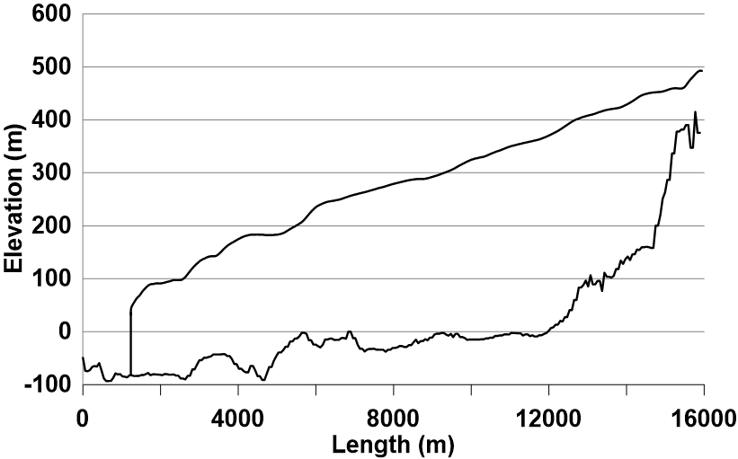
The longitudinal profile of the glacier surface is derived from continuous DEM generated from WorldView-2 satellite data (Błaszczyk et al., 2019), while profile of the bed under the glacier is interpolated from ground-penetrating radar data (Grabiec et al., 2012). Grabiec, M., Jania, J. A., Puczko, D., Kolondra, L., & Budzik, T. (2012). Surface and bed morphology of Hansbreen, a tidewater glacier in Spitsbergen. Polish Polar Research, 33(2), 111–138. https://doi.org/10.2478/v10183−012−0010−7 Błaszczyk, M., Ignatiuk, D., Grabiec, M., Kolondra, L., Laska, M., Decaux, L., Jania, J., Berthier, E., Luks, B., Barzycka, B., & Czapla, M. (2019). Quality assessment and glaciological applications of digital elevation models derived from space-borne and aerial images over two tidewater glaciers of southern Spitsbergen. Remote Sensing, 11(9), 1121. https://doi.org/10.3390/rs11091121 The database is the supplement to the paper: Małgorzata Błaszczyk, Jacek A. Jania, Michał Ciepły, Mariusz Grabiec, Dariusz Ignatiuk, Leszek Kolondra, Aleksandra Kruss, Bartłomiej Luks, Mateusz Moskalik, Tadeusz Pastusiak, Agnieszka Strzelewicz, Waldemar Walczowski, Tomasz Wawrzyniak. “Factors controlling terminus position of Hansbreen, a tidewater glacier in Svalbard”, Journal of Geophysical Research - Earth Surface, https://doi.org/10.1029/2020JF005763.
-
Average terminus height above sea level for the period 1992–1996, 2000 and 2010 was acquired with an accuracy of ±1.5 m, using terrestrial photogrammetry. The glacier terminus height in September 2009 and 2015 was measured using precise laser scanning with an accuracy of ±0.5 m. The height data obtained using photogrammetry and a laser scanner are averaged along the ice face. The database is the supplement to the paper: Małgorzata Błaszczyk, Jacek A. Jania, Michał Ciepły, Mariusz Grabiec, Dariusz Ignatiuk, Leszek Kolondra, Aleksandra Kruss, Bartłomiej Luks, Mateusz Moskalik, Tadeusz Pastusiak, Agnieszka Strzelewicz, Waldemar Walczowski, Tomasz Wawrzyniak. “Factors controlling terminus position of Hansbreen, a tidewater glacier in Svalbard”, Journal of Geophysical Research - Earth Surface, https://doi.org/10.1029/2020JF005763.
-
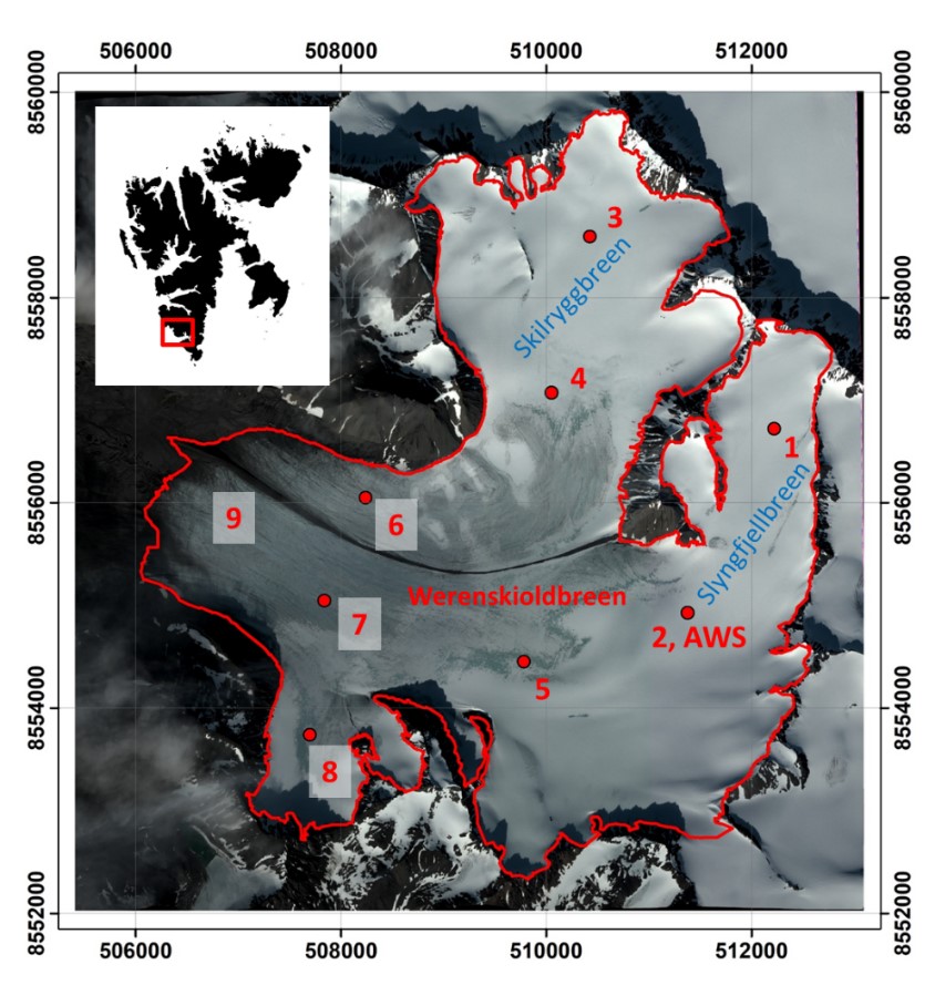
Firn extents of Hansbreen and Werenskoildbreen delivered from unsupervised classifications of single, dual and fully-polarimetric SAR data (ALOS-2 PALSAR, RADARSAT-2, Sentinel-1, ERS-2 SAR) between 2011 and 2017. Methods of classification: unsupervised ISO classification, H-a Wishart Classification. Results validated with terrestrial measurements (shallow ice cores drilling, Ground Penetrating Radar measurements). Research supported by the European Space Agency, Third Party Missions grant and Svalbard Science Forum, Arctic Field Grant 2018. For more details, please e-mail to this adress: bbarzycka@us.edu.pl.
-
https://egusphere.copernicus.org/preprints/2023/egusphere-2023-115/
-
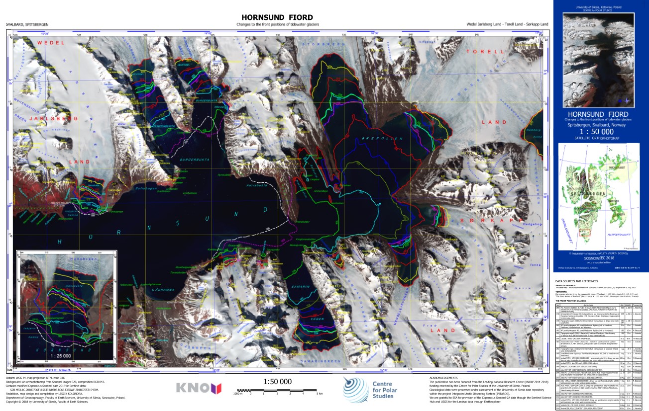
The ortophotomap of Hornsund Fiord with changes to the front positions of tidewater glaciers. The front positions are based on different cartographical maps and satellite data. The base map is Sentinel 2 satellite image acquired on 6 July 2018. Citation: Kolondra L., 2018. Hornsund Fiord - Changes to the front positions of tidewater glaciers. University of Silesia, Faculty of Earth Sciences.
-
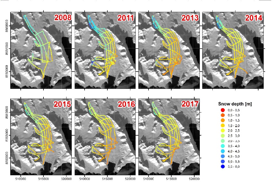
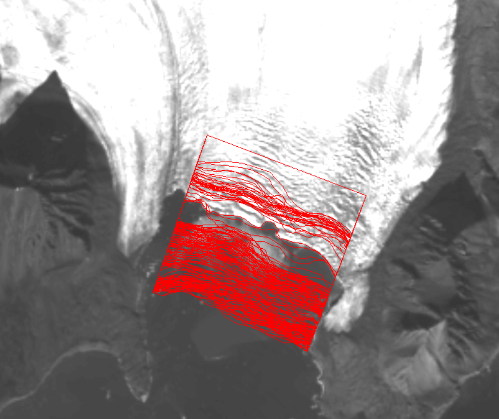
Snow depth data series contain records obtained by high frequency GPR on selected glaciers of Hornsund area (S Svalbard) since 2008. Currently the largest collection regards Hansbreen. Data for other glaciers are successively appended. The GPR survey on Hansbreen is regularly carried out approximately along the same tracks. Due to dynamically changing glacier surface topography influencing different survey abilities the some parts of profiles are modified in consecutive seasons. The total distance of Hansbreen profiles are as follows (Fig.1): 63.9 km (2008), 117,5 km (2011), 105,1 km (2013), 103,9 km (2014), 98,5 km (2015), 91,1 km (2016), 101,0 km (2017) and 108,4 km (2018).
-
• Data set of daily suspended sediment transport from the Breelva (glacier river), which drains the Werenskioldbreen (Southwestern Spitsbergen), for the period 2007–2012 (Appendix I). • Period of sampling, range of the suspended sediment concentration (SSC), total suspended sediment load (SSL), and the rate of mechanical denudation and also total annual runoff (Qtotal) from Werenskioldbreen catchment for the studied seasons (1972, 1986 and 2007–2012) (Appendix II). Detailed information can be found in: Pulina, M. Preliminary studies on denudation in SW Spitsbergen. Bull. Acad. Pol. Sci. Terre 1974, 22, 83–99. Krawczyk, W., Opołka-Gądek, J. Suspended sediment concentration in the Werenskiold Glacier drainage basin in 1986. In XXI Polar Symposium; Zalewski, M.S., Ed.; Institute of Geophysics Polish Academy of Sciences: Warszawa, Poland, 1994; pp. 215–224, ISBN 8385173374. Łepkowska E., Stachnik Ł., 2018. Which drivers control the suspended sediment flux in a High Arctic glacierized basin (Werenskioldbreen, Spitsbergen)? Water, 10, 1408. doi: https://doi.org/10.3390/w10101408