 Centre for Polar Studies
elevation
Type of resources
Topics
Keywords
Contact for the resource
Provided by
Representation types
Update frequencies
status
-
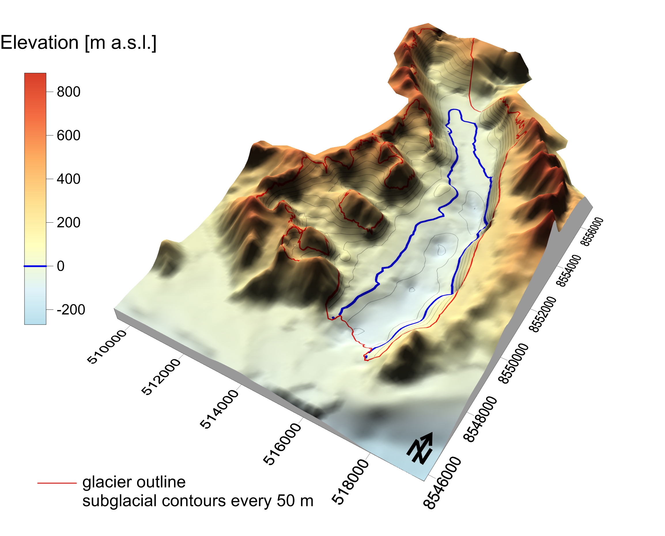
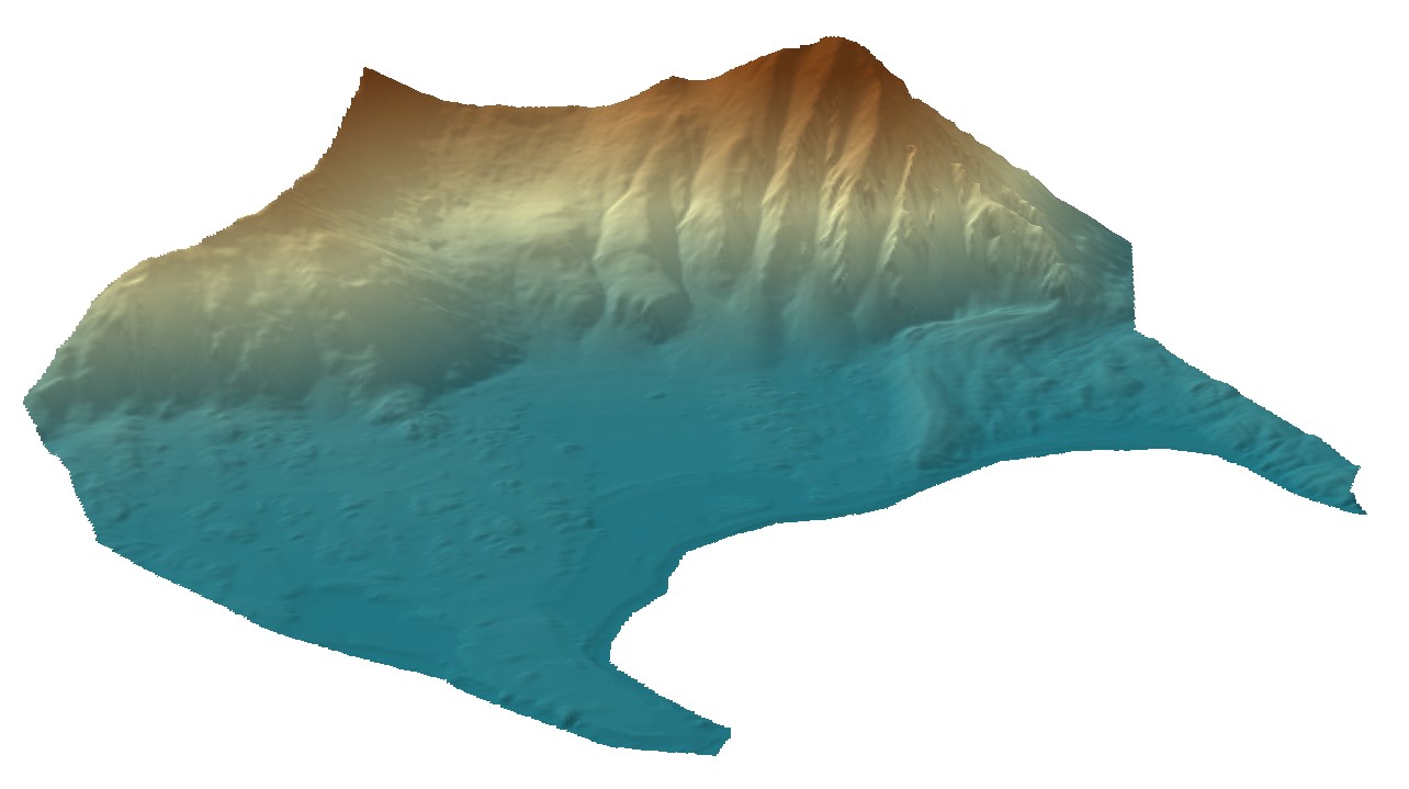
Subglacial topography was derived from radio-echo sounding (RES) survey conducted in spring 2008 by the University of Silesia research team (M. Grabiec and J. Jania) in cooperation with the Institute of Geophysics Polish Academy of Sciences (D. Puczko) and the Maria Curie-Sklodowska University (G.Gajek). The profiles were acquired by the radar system equipped with 25 MHz unshielded antenna pulled behind snowmobile. Traces were recorded every 0.5 s, that translates into 1.5-2.0 trace-to-trace distance depending on the vehicle’s velocity. Traces were positioned by GNSS receiver working in differential mode with 3D accuracy ± 1m. In total over 100 km of RES profiles were acquired on Hansbreen, 66 km on Werenskioldbreen and 43 km on Renardbreen. RES data were processed using standard procedure including: DC-offset, time-zero adjustment, 2-D filter, amplitude correction, bandpass filtering and migration. Time-to-depth conversion applied average radio-wave velocity in glacier ice 16.4 cm ns-1 calculated based on CMP analysis performed on Hansbreen in the same season as the GPR profiling. The ice/bed interface was picked up semi-automatically with RMSE 5.3 ns (0.43 m) (Grabiec, 2017). Then the bedrock elevation data were interpolated over studied glaciers taking into account elevation of nonglaciated surroundings (Grabiec 2017) and bathymetry at the front of tidewater Hansbreen (Grabiec et al. 2012). Finally produced 100 m resolution DEMs are in UTM 33X WGS84 reference system. DEM of 300 m resolution is freely available. For 100 m resolution DEM please contact: mariusz.grabiec@us.edu.pl. The data were collected and processed under following projects: • IPY/269/2006 GLACIODYN The dynamic response of Arctic glaciers to global warming • UE FP7-ENV-2008-1 ice2sea Estimating the future contribution of continental ice to sea-level rise • PNRF-22-AI-1/07 AWAKE Arctic Climate and Environment of the Nordic Seas and the Svalbard – Greenland Area • 03/KNOW2/2014 KNOW Leading National Research Centre Reference: Grabiec M., Jania J., Puczko D., Kolondra L., and Budzik T., 2012: Surface and bed morphology of Hansbreen, a tidewater glacier in Spitsbergen. Polish Polar Research 38(2): 111-138. Grabiec M. 2017: Stan i współczesne zmiany systemów lodowcowych południowego Spitsbergenu w świetle badań metodami radarowymi. Wydawnictwo Uniwersytetu Śląskiego, 328 s. Decaux, L., Grabiec, M., Ignatiuk, D., and Jania, J. 2018: Role of discrete recharge from the supraglacial drainage system for modelling of subglacial conduits pattern of Svalbard polythermal glaciers, The Cryosphere Discuss., https://doi.org/10.5194/tc-2017-219, in review.
-
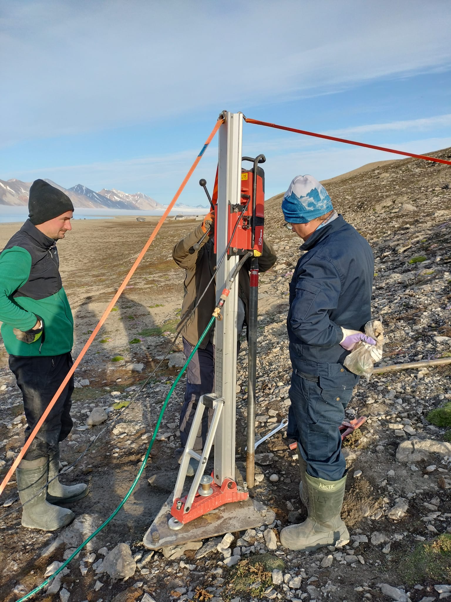
Permafrost monitoring System of thermistors (temperature strings with loggers) to monitor the ground thermal state Precise data on the thermal state of the frozen ground is one of the key missing components of the environmental monitoring at the research stations spread across Spitsbergen. The CRIOS project will allow us to equip the newly established borehole with precise temperature strings that will record ground thermal changes over the next couple of years. A system of temperature strings will be used in the monitoring of the thermal state of permafrost in drilled boreholes. Devices were tested in severe weather and are commonly used for permafrost monitoring by other research groups working in polar regions. Site Information The borehole near the UMK station in Kaffioyra was located at the existing meteorological garden, about 100 m from the shoreline. The drilling was carried out on 20-21.07.2023. The substrate is dominated by loose sandy-gravel beach sediments. A large amount of fine material and the formation of a core in a small part of the hole made it possible to reach a depth of 10.0 m below sea level. CRIOS – Cryosphere Integrated Observation Network on Svalbard Project financed from the EEA Financial Mechanism 2014-2021 operated by the National Science Centre in Poland Agreement no. UMO-2022/43/7/ST10/00001 to a predefined project no. 2022/43/7/ST10/00001 Project period: 08.09.2022 - 30.04.2024 (2029)
-
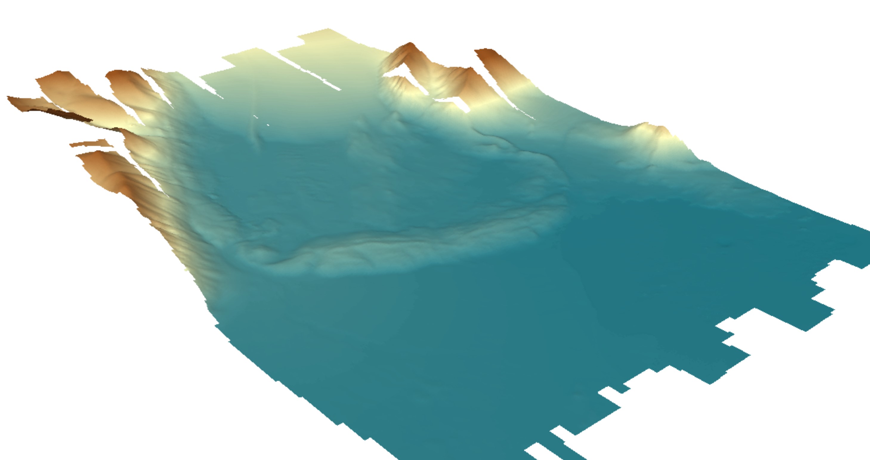
Digital elevation model (DEM) with high spatial resolution derived from aerial images captured in 2020 over Hornsund, Svalbard by Dornier aircraft. The spatial resolution of the orthomosaic is 0.174 m. Aerial images for the area were provided by the SIOS through a dedicated call of proposals (https://sios-svalbard.org/AirborneRS). The dataset is the supplement to the paper: Błaszczyk, M.; Laska, M.; Sivertsen, A.; Jawak, S.D. Combined Use of Aerial Photogrammetry and Terrestrial Laser Scanning for Detecting Geomorphological Changes in Hornsund, Svalbard. Remote Sens. 2022, 14, 601. https://doi.org/10.3390/rs14030601
-
Digital elevation model (DEM) with high spatial resolution derived from aerial images captured in 2020 over Hornsund, Svalbard by Dornier aircraft. The spatial resolution of the orthomosaic is 0.169 m. Aerial images for the area were provided by the SIOS through a dedicated call of proposals (https://sios-svalbard.org/AirborneRS). The dataset is the supplement to the paper: Błaszczyk, M.; Laska, M.; Sivertsen, A.; Jawak, S.D. Combined Use of Aerial Photogrammetry and Terrestrial Laser Scanning for Detecting Geomorphological Changes in Hornsund, Svalbard. Remote Sens. 2022, 14, 601. https://doi.org/10.3390/rs14030601
-
%20data%20for%20Fuglebergsletta%20area.jpg)
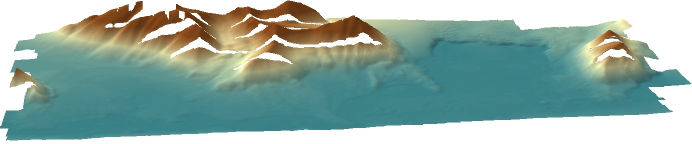
Point cloud collected using the Riegl VZ®-6000 long-range terrestrial laser scanner. The TLS survey was carried out on 15th August 2021. The dataset is the result of relative and absolute registration of four point clouds. The dataset is the supplement to the paper: Błaszczyk, M.; Laska, M.; Sivertsen, A.; Jawak, S.D. Combined Use of Aerial Photogrammetry and Terrestrial Laser Scanning for Detecting Geomorphological Changes in Hornsund, Svalbard. Remote Sens. 2022, 14, 601. https://doi.org/10.3390/rs14030601
-
Digital elevation model (DEM) combined from DEM derived from aerial images captured in 2020 over Hornsund, Svalbard by Dornier aircraft and from terrestrial laser scanner campaign in 2021. Both DEMs contain data gaps; therefore, they were combined to create a continuous product with the best possible accuracy and resolution. The dataset is the supplement to the paper: Błaszczyk, M.; Laska, M.; Sivertsen, A.; Jawak, S.D. Combined Use of Aerial Photogrammetry and Terrestrial Laser Scanning for Detecting Geomorphological Changes in Hornsund, Svalbard. Remote Sens. 2022, 14, 601. https://doi.org/10.3390/rs14030601