height of the terminus
Type of resources
Topics
Keywords
Contact for the resource
Provided by
Representation types
Update frequencies
status
-

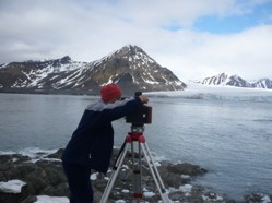
Average terminus height above sea level for the period 1992–1996, 2000 and 2010 was acquired with an accuracy of ±1.5 m, using terrestrial photogrammetry. The glacier terminus height in September 2009 and 2015 was measured using precise laser scanning with an accuracy of ±0.5 m. The height data obtained using photogrammetry and a laser scanner are averaged along the ice face. The database is the supplement to the paper: Małgorzata Błaszczyk, Jacek A. Jania, Michał Ciepły, Mariusz Grabiec, Dariusz Ignatiuk, Leszek Kolondra, Aleksandra Kruss, Bartłomiej Luks, Mateusz Moskalik, Tadeusz Pastusiak, Agnieszka Strzelewicz, Waldemar Walczowski, Tomasz Wawrzyniak. “Factors controlling terminus position of Hansbreen, a tidewater glacier in Svalbard”, Journal of Geophysical Research - Earth Surface, https://doi.org/10.1029/2020JF005763.
 Centre for Polar Studies