From 1 - 10 / 38
  • Categories    

    Changes in position of glacier front are obtained from a Riegl FG21-LR laser distance ranger (the temporal resolution of 10 minutes) taken during September 2009 – February 2013. The database is the supplement to the paper: Małgorzata Błaszczyk, Jacek A. Jania, Michał Ciepły, Mariusz Grabiec, Dariusz Ignatiuk, Leszek Kolondra, Aleksandra Kruss, Bartłomiej Luks, Mateusz Moskalik, Tadeusz Pastusiak, Agnieszka Strzelewicz, Waldemar Walczowski, Tomasz Wawrzyniak. “Factors controlling terminus position of Hansbreen, a tidewater glacier in Svalbard”, Journal of Geophysical Research - Earth Surface, https://doi.org/10.1029/2020JF005763.

  • Categories    

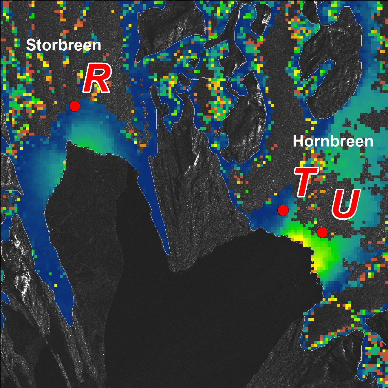
    Glacier velocities are derived from the displacements of stakes installed close to the front of Hansbreen. Measurements of stakes position were conducted in 2008-2009, 2010-2011, 2013-2014 and 2015, with precise dGPS receiver (Leica 1230, accuracy ±5cm) and with time intervals from 3 hours to a few days.

  • Categories    

    Dataset contains results of GPR survey performed with 800 MHz antennas for snow depth calculation. Fieldwork has been done during peak of accumulation, along repeated profiles on several glaciers in the region of Hornsund, Svalbard: Amundsenisen (2013) Werenskioldbreen (2013, 2014, 2015) Nannbreen (2013) Ariebreen (2014) Flatbreen (2018) Storbreen (2018) Acknowledgements: Research Council of Norway, Arctic Field Grant 2013: Spatial distribution of snow cover and drainage systems on the glaciers on Wedel Jarlsberg Land (RiS ID: 6158); the National Science Centre PRELUDIUM 4: Role of meltwater from snow cover for supplying drainage systems of the Spitsbergen glaciers (2012/07/N/ST10/03784); References: LASKA M.,GRABIEC M.,IGNATIUK D.,BUDZIK T.,2017. Snow deposition patterns on southern Spitsbergen glaciers, Svalbard, in relation to recent meteorological conditions and local topography. Geografiska Annaler, Series A: Physical Geography, 99(3): 262–287. doi:10.1080/04353676.2017.1327321

  • Categories    

    The position of the terminus of Hansbreen is derived with very high frequency in the period 1991–2015. Over 160 multispectral and Synthetic Aperture Radar (SAR) data were used: LANDSAT 5, LANDSAT 7, LANDSAT 8, Terra ASTER, Alos AVNIR, SPOT 5, ERS-1, ERS-2, ENVISAT, Alos PALSAR, TerraSAR-X, TanDEM-X, and Sentinel-1. Terra ASTER images were orthorectified with use of 2008 DEM SPOT and geocoded in PCI Geomatica and ArcGIS software. Multispectral, already terrain-corrected images were rectified in ArcGIS software. SAR data were provided at the Single Look Complex level and that both radiometric and geometric corrections were applied using the same methods, and with the same digital elevation model (2008 DEM SPOT). The SAR data were processed in BEAM (http://www.brockmann-consult.de/cms/web/beam). Sentinel data downloaded from the Sentinel’s Data Hub were already processed. The satellite data were digitized manually to obtain the front position. The database is the supplement to the paper: Małgorzata Błaszczyk, Jacek A. Jania, Michał Ciepły, Mariusz Grabiec, Dariusz Ignatiuk, Leszek Kolondra, Aleksandra Kruss, Bartłomiej Luks, Mateusz Moskalik, Tadeusz Pastusiak, Agnieszka Strzelewicz, Waldemar Walczowski, Tomasz Wawrzyniak. “Factors controlling terminus position of Hansbreen, a tidewater glacier in Svalbard”, Journal of Geophysical Research - Earth Surface, https://doi.org/10.1029/2020JF005763.

  • Categories    

    Inventory of tidewater and landbased glaciers delineated from archival satellite images (ASTER, Landsat) for Southern Spitsbergen. Tidewater glaciers are delineated based on satellite data from 2010. Landbased glacier are extracted from different satellite data (2005-2010). Shapefiles have basic information in the attribute table (name, ID, area, type of glaciers). Detailed description of the source data and accuracy data for glaciers from hydrological basin of Hornsund can be found in: Błaszczyk M., Jania J.A., Kolondra L., 2013: Fluctuations of tidewater glaciers in Hornsund Fiord (Southern Svalbard) since the beginning of the 20th century. Polish Polar Research, 34( 4): 327-352.http://journals.pan.pl/dlibra/publication/114504/edition/99557/content

  • Categories    

    Dataset contains location of glacial shafts (moulins) on two polythermal glaciers: Werenskioldbreen and Hansbreen. Fieldwork has been done with GPS device at the end of ablation season in 2015. Acknowledgements: Research Council of Norway, Arctic Field Grant 2013: Spatial distribution of snow cover and drainage systems on the glaciers on Wedel Jarlsberg Land (RiS ID: 6158); the National Science Centre PRELUDIUM 4: Role of meltwater from snow cover for supplying drainage systems of the Spitsbergen glaciers (2012/07/N/ST10/03784)

  • Categories    

    High resolution orthophoto images from Geoeye, WorldView-2 and Pléaides processed in OrthoEngine module of PCI Geomatica. Data format: grid, UTM 33X / EGM 2008. Spatial resolution: 0.5 m (panchromatic and pansharpened) and 2 m (multispectral).

  • Categories    

    The base contain: 1. List (*xls) of terrophotogrammetric photographs taken by member of Polish Expedition on Iceland in 1968 (zone of Skeidarárjökull). 2. Skaning above photographs with resolution of 2400 dpi, file format *.tif and *.jpg (400 dpi). All photographs were taken by means of instrument type Phototheodolite Zeiss 19/1318 on glass plates. Authors of photographs: Tadeusz Konysz. Fot better identification of all photographs was prepared presentations (in *.pptx and *.pdf formats), where photographs there are arranged in in common practise, classic form used for terrophotogrammetric stereoscopic photographs: A, AL, AR, B, BL, BR (the meaning of a letter: A - right photogrammetric station and photograph taken in normal case [90°]; B - left photogrammetric station and photograph taken in normal case [90°]; AL - photograph taken from right station in left direction; AR - photograph taken from right station in right direction; BL - photograph taken from left station in left direction; BR - photograph taken from left station in right direction). Other photographs (e.g. panoramic) has additional informations. All names of photogrammetric stations and name of objects (in Polish language) was taken from the author’s collection of data.

  • Categories    

    • Discharge measurements were conducted from May/June/July to September/October in the years 2007–2012. Direct observation periods were 62, 51, 61, 40, 121, and 35 days in the consecutive years. The data set was obtained from CTD-DIVER DI 261 or Mini-Diver (Van Essen Instruments, Delft, The Netherlands) logger with barometric compensation by BaroDiver (Schlumberger, Houston, TX, USA) with 10-min intervals and flow velocities were measured with a SEBA F1 current meter (SEBA Hydrometrie GmbH, Kaufbeuren, Germany). Mean daily discharge and total runoff in the hydrologically active season was calculated on the basis of the 24h running average of the water level and a rating curve (Appendix 1). More details have been reported by Majchrowska E., Ignatiuk D., Jania J., Marszałek H., Wąsik M., 2015: Seasonal and interannual variability in runoff from the Werenskioldbreen catchment, Spitsbergen. Polish Polar Research vol. 36, no. 3, pp. 197–224. doi: 10.1515/popore−2015−0014 • Hydrological data for Werenskioldbreen - archive of the University of Silesia. The base contain mean daily discharge in the years: 1970, 1971, 1972, 1973, 1974, 1979, 1980, 1983, 1985, 1986, 1988, 1998, 2007, 2008, 2009, 2010, 2011, 2012, 2013, 2017, 2019 (21 hydrologically active seasons) – Appendix 2

  • Categories    

    Bathymetry at the front of tidewater glaciers derived from different sources. Bathymetry data in Hansbukta and Burgerbukta have been collected by the Norwegian Hydrographic Service using a multi-beam survey during 2007–2008. Later measurements in Hansbukta were collected with single beam profiling at the Hansbreen front in 2015. Data format: grid (6m), UTM 33X. Single echo-sounding data collected during summer 2011, by the University of Silesia.