 Polish Polar DataBase
Changes of glaciers facies of Hansbreen, Storbreen and Flatbreen from 2008 to 2018
Glaciers facies (ice, superimposed ice, firn) extents of Hansbreen, Storbreen and Flatbreen delivered from unsupervised classifications of single, dual and fully-polarimetric SAR data (ALOS-2 PALSAR, RADARSAT-2, Sentinel-1, ERS-2 SAR) between 2008 and 2018. Methods of classification: unsupervised ISO classification, H-a Wishart Classification. Results validated with terrestrial measurements (shallow ice cores drilling, Ground Penetrating Radar measurements). Research supported by the European Space Agency, Third Party Missions grant and Svalbard Science Forum, Arctic Field Grant 2018. For more details, please e-mail to
bbarzycka@us.edu.pl.
Simple
- Date (Publication)
- 2020-12
- Purpose
- scientific and didactic
- Status
- On going
- Maintenance and update frequency
- As needed
- Theme
-
- glaciers facies, glaciers zones, SAR, full-polarimetry, classification, firn line, ELA
- Place
-
- Hansbreen, Storbreen, Flatbreen, Hornsund, Spitsbergen, Svalbard
- Access constraints
- Intellectual property rights
- Use constraints
- Intellectual property rights
- Spatial representation type
- Grid
- Metadata language
- eng
- Character set
- UTF8
- Topic category
-
- Geoscientific information
- Begin date
- 2008-04-26
- End date
- 2018-04-26
N
S
E
W
))
- Reference system identifier
- WGS_1984_UTM_Zone_33N
- OnLine resource
- Overwiew of glaciers facies extents of Hansbreen in 2008 and 2015 with comparison to visual interpretation of GPR data. ( WWW:DOWNLOAD-1.0-http--download )
- OnLine resource
-
Extended human readable information about the dataset
(
WWW:LINK-1.0-http--link
)
Extended human readable information about the dataset
- Hierarchy level
- Dataset
- File identifier
- 4b074a4f-155c-4876-8441-22be58ad39a6 XML
- Metadata language
- English
- Character set
- UTF8
- Date stamp
- 2020-12-09T11:47:13
- Metadata standard name
- ISO 19115:2003/19139
- Metadata standard version
- 1.0
Overviews
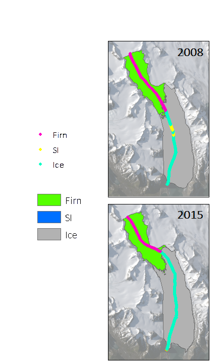
Overwiew of glaciers facies extents of Hansbreen in 2008 and 2015 with comparison to visual interpretation of GPR data.
Spatial extent
N
S
E
W
Provided by

Associated resources
Not available