 Polish Polar DataBase
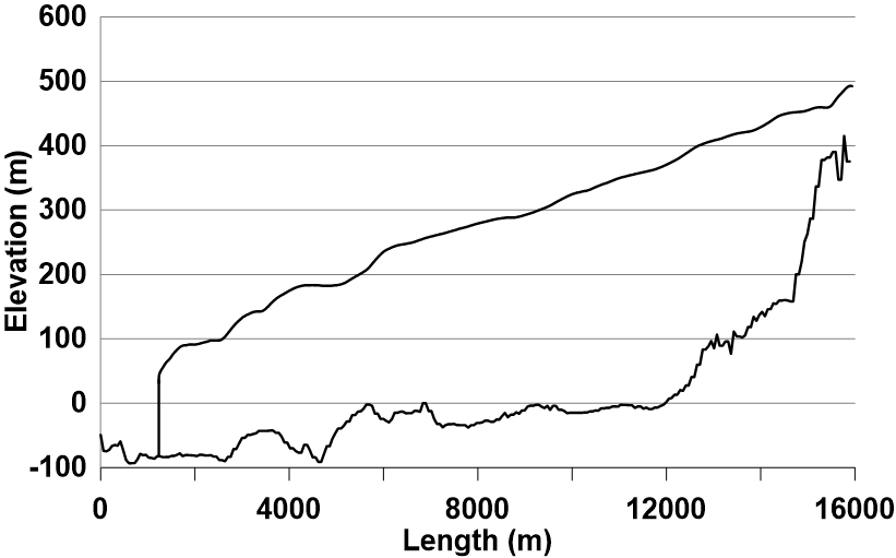
Longitudinal profiles of Hansbreen bed and surface
The longitudinal profile of the glacier surface is derived from continuous DEM generated from WorldView-2 satellite data (Błaszczyk et al., 2019), while profile of the bed under the glacier is interpolated from ground-penetrating radar data (Grabiec et al., 2012).
Grabiec, M., Jania, J. A., Puczko, D., Kolondra, L., & Budzik, T. (2012). Surface and bed morphology of Hansbreen, a tidewater glacier in Spitsbergen. Polish Polar Research, 33(2), 111–138. https://doi.org/10.2478/v10183−012−0010−7
Błaszczyk, M., Ignatiuk, D., Grabiec, M., Kolondra, L., Laska, M., Decaux, L., Jania, J., Berthier, E., Luks, B., Barzycka, B., & Czapla, M. (2019). Quality assessment and glaciological applications of digital elevation models derived from space-borne and aerial images over two tidewater glaciers of southern Spitsbergen. Remote Sensing, 11(9), 1121. https://doi.org/10.3390/rs11091121
The database is the supplement to the paper: Małgorzata Błaszczyk, Jacek A. Jania, Michał Ciepły, Mariusz Grabiec, Dariusz Ignatiuk, Leszek Kolondra, Aleksandra Kruss, Bartłomiej Luks, Mateusz Moskalik, Tadeusz Pastusiak, Agnieszka Strzelewicz, Waldemar Walczowski, Tomasz Wawrzyniak. “Factors controlling terminus position of Hansbreen, a tidewater glacier in Svalbard”, Journal of Geophysical Research - Earth Surface, https://doi.org/10.1029/2020JF005763.
Simple
- Date (Publication)
- 2020-11-07
- Status
- Completed
- Maintenance and update frequency
- As needed
- Theme
-
- glacier surface, glacier bedrock
- Place
-
- Hansbreen, Southern Spitsbergen, Svalbard, Norway
- theme.GMCD_ScienceKeywords.rdf
-
- GLACIER ELEVATION/ICE SHEET ELEVATION
- GLACIER TOPOGRAPHY/ICE SHEET TOPOGRAPHY
- GLACIER/ICE SHEET TOPOGRAPHY
- GLACIER THICKNESS/ICE SHEET THICKNESS
- GLACIER/ICE SHEET THICKNESS
- Access constraints
- License
- Use constraints
- License
- Other constraints
- CC BY-NC-SA 4.0
- Spatial representation type
- Text, table
- Metadata language
- English
- Character set
- UTF8
- Topic category
-
- Boundaries
))
- Supplemental Information
-
You can customize the template to suit your needs.
You can add
and remove fields and fill out default information (e.g. contact
details).
Fields you can not change in the default view may be accessible in the
more
comprehensive (and more complex) advanced view. You can even use the
XML editor
to create custom structures, but they have to be validated by the
system, so
know what you do :-)
- Reference system identifier
- WGS 1984
- OnLine resource
- Longitudinal profiles of Hansbreen bed and surface ( WWW:DOWNLOAD-1.0-http--download )
- Hierarchy level
- Dataset
Overviews
Spatial extent
Provided by
