 Polish Polar DataBase
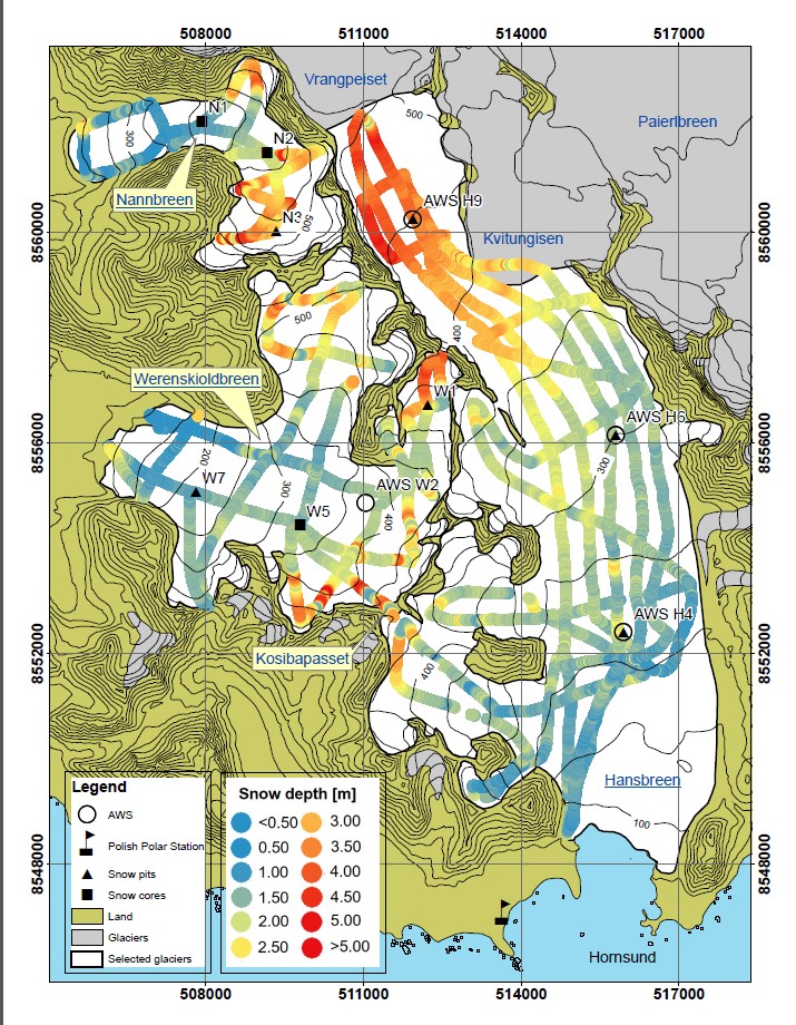
Snow depth measurements using ground penetrating radar (GPR) - Spitsbergen
Dataset contains results of GPR survey performed with 800 MHz antennas for snow depth calculation. Fieldwork has been done during peak of accumulation, along repeated profiles on several glaciers in the region of Hornsund, Svalbard:
Amundsenisen (2013)
Werenskioldbreen (2013, 2014, 2015)
Nannbreen (2013)
Ariebreen (2014)
Flatbreen (2018)
Storbreen (2018)
Acknowledgements: Research Council of Norway, Arctic Field Grant 2013: Spatial distribution of snow cover and drainage systems on the glaciers on Wedel Jarlsberg Land (RiS ID: 6158); the National Science Centre PRELUDIUM 4: Role of meltwater from snow cover for supplying drainage systems of the Spitsbergen glaciers (2012/07/N/ST10/03784);
References: LASKA M.,GRABIEC M.,IGNATIUK D.,BUDZIK T.,2017. Snow deposition patterns on southern Spitsbergen glaciers, Svalbard, in relation to recent meteorological conditions and local topography. Geografiska Annaler, Series A: Physical Geography, 99(3): 262–287. doi:10.1080/04353676.2017.1327321
- Identification
- Distribution
- Quality
- Spatial rep.
- Ref. system
- Content
- Portrayal
- Metadata
- Md. constraints
- Md. maintenance
- Schema info
Identification
Data identification
Citation
- Date (Publication)
- 2020-12
- Purpose
- scientific and didactic
- Status
- On going
- Maintenance and update frequency
- Annually
- Theme
-
- snow cover, gpr
- Place
-
- Spitsbergen, Svalbard, Arctic, Norway
Legal constraints
- Access constraints
- Intellectual property rights
- Use constraints
- Intellectual property rights
- Spatial representation type
- Text, table
- Metadata language
- English
- Character set
- UTF8
- Topic category
-
- Environment
- Begin date
- 2013-01-01
- End date
- 2018-12-31
))
Distribution
Digital transfer options
- OnLine resource
-
GPR_data overwiev
(
WWW:DOWNLOAD-1.0-http--download
)
Description of available data
- OnLine resource
-
Extended human readable information about the dataset
(
WWW:LINK-1.0-http--link
)
Extended human readable information about the dataset
Quality
Data quality
- Hierarchy level
- Dataset
Ref. system
- Reference system identifier
- WGS 1984
Metadata
Metadata
- File identifier
- 9024e8c6-0431-466e-bdbe-58458a227464 XML
- Metadata language
- English
- Character set
- UTF8
- Date stamp
- 2020-12-09T11:47:16
- Metadata standard name
- ISO 19115:2003/19139
- Metadata standard version
- 1.0
Overviews
Spatial extent
Provided by
